|


Help Support
the Children's Hospice Association Scotland
| |
Jura
Island of the Deer
An
island of 160 people, 5,000 red deer and one fine malt distillery.
So says the
introduction on the website for the one and only distillery on Jura.
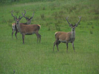 Jura is
known as the island of the deer for obvious reasons. While it is almost
100% likely that a visit to the island will result in many of these majestic
animals being seen, there are many other reasons to visit. Another attraction
the island offers is isolation. Despite its size,
around thirty miles long and at most nine miles wide, Jura is sparsely
populated, as stated above,
and most of the
island can only be visited on foot. Jura is
known as the island of the deer for obvious reasons. While it is almost
100% likely that a visit to the island will result in many of these majestic
animals being seen, there are many other reasons to visit. Another attraction
the island offers is isolation. Despite its size,
around thirty miles long and at most nine miles wide, Jura is sparsely
populated, as stated above,
and most of the
island can only be visited on foot.
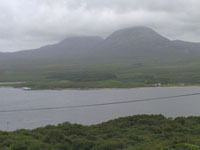
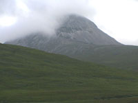
Dominating
the view of Jura from almost any direction are the three, distinctive and easily
recognised, Paps of Jura found in the southern half of the island. The
highest of the three is Beinn an Oir, the mountain of gold, is 785m/2576
ft is the only Corbett, a mountain in Scotland between 2500 and 3000 ft.
Beinn
Shiantaidh, the holy mountain, is 757m/2477 ft and stands to the east of
Beinn an
Oir, while
Beinn a'
Chaolais, the mountain of the sound,
stands to the
south-west and is the smallest of the three at 734m/2407 ft. Cora Bheinn, the steep mountain, stands at a height of 569 m/1893 ft to
the north-east of
Beinn
Shiantaidh and, while not considered to be one of the Paps, is part of
the same group of mountains.
 To get to Jura,
the majority of people will require a visit to the neighbouring, larger, island
of Islay, which is located to the south-west of Jura and separated from the
smaller island by the half mile wide stretch of water known as the Sound of
Islay. The ferry between the two islands runs from Port Askaig, on the east
coast of Islay, to Feolin, in the south-west corner of Jura. From Feolin, the single-track A846 heads round the southern end of the island
and then along the eastern side giving most visitors access to as much of the
island as is possible by car. To get to Jura,
the majority of people will require a visit to the neighbouring, larger, island
of Islay, which is located to the south-west of Jura and separated from the
smaller island by the half mile wide stretch of water known as the Sound of
Islay. The ferry between the two islands runs from Port Askaig, on the east
coast of Islay, to Feolin, in the south-west corner of Jura. From Feolin, the single-track A846 heads round the southern end of the island
and then along the eastern side giving most visitors access to as much of the
island as is possible by car.
Jura House, which
is located at the southern end of the island, was built around 1880 by the
Campbell’s of Jura. The walled garden was created in the early part of the 19th
century and acted as a kitchen garden to the house. The garden is now open to
the public. There are a couple of small islands situated off the southern coast
of Jura, Am Fraoch Eilean to the south-west of Jura House and Brosdale Island to
the south-east. On the first of these are the remains of Claig Castle, one of
the sea fortresses that were used by by the Lords of the Isles to control traffic in the
seas around the Hebridean islands.
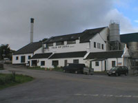 From
Jura House, the road heads north-west towards Craighouse, the only village on
Jura and the location of the island’s only distillery as well as the only hotel.
The village sits overlooking a bay with a group of islands that are known
collectively as the Small Isles. Beyond these islands, Knapdale on the
mainland is separated from Jura by the stretch of water known as the Sound of
Jura. From
Jura House, the road heads north-west towards Craighouse, the only village on
Jura and the location of the island’s only distillery as well as the only hotel.
The village sits overlooking a bay with a group of islands that are known
collectively as the Small Isles. Beyond these islands, Knapdale on the
mainland is separated from Jura by the stretch of water known as the Sound of
Jura.
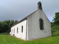 Jura
Parish Church can also be found in Craighouse and was built in 1777. A room to
the rear of the building contains an exhibition of photographs dating back to
the early 20th century. There is no charge to view the photographs or
enter the church, but donations are welcome. Jura
Parish Church can also be found in Craighouse and was built in 1777. A room to
the rear of the building contains an exhibition of photographs dating back to
the early 20th century. There is no charge to view the photographs or
enter the church, but donations are welcome.
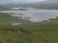
To the north of
Small Isles Bay, immediately after the main road has crossed the Corran
River, a turning to the right leads to Knockrome and Ardfernal. The river runs
into Loch na Mile to the south while Ardfernal overlooks Lowlandman’s Bay to the
north-east, which is almost completely closed off by the rocky promontory known
as Rubh’an Leim.
 Back
on the main road and heading north once more,
Beinn
Shiantaidh rises up to the west giving as close a view as possible of one of the
Paps without having to leave the road.
Lagg, which used
to be a ferry port for Knapdale especially during the period when cattle droving
was common, is closely followed by Tarbert. Back
on the main road and heading north once more,
Beinn
Shiantaidh rises up to the west giving as close a view as possible of one of the
Paps without having to leave the road.
Lagg, which used
to be a ferry port for Knapdale especially during the period when cattle droving
was common, is closely followed by Tarbert.
 At this point
Jura is almost cut in two by Loch Tarbert that slices into the western side of
the island, with Tarbert in the east only being a mile from the tip of the loch
itself. The main road continues north, but not for much further. At this point
Jura is almost cut in two by Loch Tarbert that slices into the western side of
the island, with Tarbert in the east only being a mile from the tip of the loch
itself. The main road continues north, but not for much further.
Near Ardlussa,
just after crossing the Lussa River, the road, which has now narrowed even more
than it already was, splits, with the southern branch heading towards Inverlussa
where the river enters the bay of the same name. Meanwhile the other branch
continues north-east almost reaching that end of the island, although by the
time it reaches its final destination it can barely be described as a road.
Near the northern
tip of Jura is Barnhill, the cottage where Eric Blair, who is better
known as George Orwell, lived from 1946-48 while writing his novel 1984.
Orwell had first visited the island in 1945 and had an almost fatal encounter in
the Gulf of Corryvreckan that separates Jura from the smaller
island of Scarba to the north. One day in 1947, Blair had taken a break from
writing to sail with his nephews and nieces. However, their boat was caught by
the whirlpool that the gulf is famous for and, despite losing the boat, Blair
and the youngsters managed to reach a small rock where they were later picked up
by a fishing boat. Blair returned to Barnhill where he finished his novel,
although had things turned out differently on that day in the gulf the world
might not have read about Big Brother.
| |

See our bookshop in
association with
amazon.co.uk!

Advert
|